Tuesday, June 15, 2010
Moab, UT to Bluff, UT
View Larger Map
Today's Stats
Miles: 100.59
Riding Time: 6:57:35
Avg. Speed: 14.4
Max Speed: 40.1
Elevation Gain: 5680
Today was a day of ups and downs. The toughest day of riding so far. We started with a 12 mile uphill slog out of Moab with the last mile pitching up steeply. After a short downhill we climbed up again. This up and a little bit down pattern continued for 65 miles. At that point we had reached an elevation of over 7000 ft. and had climbed over 5200 ft. in a little over 5 hours. Did I mention the headwind? We were two very demoralized, middle-aged, in over our heads, this bucket list thing is overrated guys.
The last 35 miles was much more to our liking! Only 480 ft. of climbing which meant a lot of downhill. Still in headwind but at that point it was like a horse to the barn; nothing was slowing us down!
Now for a great steak dinner at the Cottonwood Steak House and off to bed. The over 140 mile ride tomorrow in increasing southerly winds will require a lot of rest tonight. Wish us luck!
Sorry, no pictures today. Having computer problems, again. We will try to upload some tomorrow.
Monday, June 14, 2010
Monday Pictures
The only tree for miles. At the Utah line the road turned to gravel


The old Dewey Bridge. Hard boiled eggs make a good morning snack


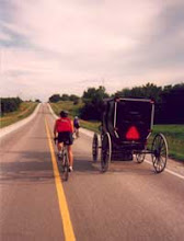
Of course this is the right road. It's the only road!


The old Dewey Bridge. Hard boiled eggs make a good morning snack


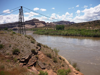
We spent a lot of time looking at the Colorado River and Navajo Sandstone cliffs.


Of course this is the right road. It's the only road!


Fruita, CO to Moab, UT
View Larger Map
Today's Stats
Miles: 92.77
Riding Time: 5:53:34
Avg. Speed: 15.7
Max Speed: 31.3
Elevation Gain: 2395 ft.
Today we said several goodbyes. We said goodbye to Bekkey. Someone has to go back to work, right? We said goodbye to Colorado. We also said goodbye to Interstate 70 and are now riding south. My guess is that we said goodbye to cool temperatures!!!
The ride out of Fruita to Loma and Mack was through farming country. Cattle and alfalfa mostly. When we entered Utah U.S. Highway 6 turned into gravel. Can you believe that? After a few miles of that nonsense the road was again paved and led us to Interstate 70. Just a quick 15 miles on Interstate 70 and then we turned south to reach Moab.
Utah State Road 128 led us across a barren landscape. The joke at that point was that we could ride with our heads down for 10 miles and not miss a change in scenery! A half hour later we joined the Colorado river again and had a spectacular ride along the river to Moab.
We probably could have ridden faster but we found ourselves gawking at the bank-full river, the massive Navajo Sandstone buttes and monoliths and the rafters on the river.
Sunday, June 13, 2010
Some pictures!!


Glenwood Springs, CO to Fruita, CO
View Larger Map
Today's Stats
Miles: 100.26
Riding Time: 5:20:01
Avg. Speed: 18.7
Max Speed: 32.5
Elevation Gain: 1460 ft.
Today was our first century!! No, I did not ride around the parking lot of the motel to reach 100 miles! It was a true 100. Today was our first flat tire, as well. Luckily, it was within a few hundred yards of our first stop.
The original plan was to ride frontage roads and Highway 6 most of the way and only ride on Interstate 70 when necessary. After riding on Interstate 70 out of Glenwood Springs we found the experience to be quite safe as the shoulder is huge and fairly free of debris. So we decided to stay on Interstate 70 all the way to Grand Junction, about 90 of our 100 miles.
The weather was very nice in spite of the rain, snow and hail that most of Colorado is experiencing. Except for the hour of rain yesterday we have been very fortunate with weather conditions.
Today's route followed the Colorado River. It is running very high. As high as I have seen it. Since we were following the river, most of ride was a gentle downward slope which was countered by a brisk headwind for the last 50 miles.
You might be wondering how we could have 1460 feet of elevation gain when most of the ride was downhill and our ending elevation is lower then our beginning elevation. Cyclists, at least this one, measure the workrate of a ride by the mileage and the amount of climbing. So any hills that are climbed are added together to come up with the elevation gain. My bike computer calculates this automatically.
Ken, Kevin's father-in-law has now joined as our support vehicle driver for the rest of the ride. Bekkey will be heading home tomorrow. She did a great job! Ken has a challenge to do as good a job as his daughter!
Rib City was our restaurant of choice tonight. If you recall from the preview, this is where all this madness began.
Saturday, June 12, 2010
Keystone, CO to Glenwood Springs, CO
View Larger Map
Today's Stats
Miles:82.45
Riding Time: 4:43:28
Avg. Speed: 17.4
Max Speed: 43.6
Elevation Gain: 3120
Today was our drama day!
Morning temperature was 30 degrees. Cold, but no complaining as the heat will come soon enough! The rain chased us most of the day. When we stopped for a break the rain would soon find us and we then had to ride on to get away from it; at least in the morning.
At Copper Mountain we encountered about 300 runners using the trail for an organized 10K and half marathon. Five minutes faster and we would have passed them at the starting line.
The descent off of Vail Pass was fast and required sharp bike handling skills because there was a trail clean up crew picking up trash and many of them insisted on standing on the trail or crossing the trail without looking for any bikers. In their defense, who would be nuts enough to ride Vail Pass on a cold wet morning like we had today!
After Vail we had sunny and windy weather for about 40 miles. We stripped off the cold weather clothing and enjoyed the downhill in a hurricane. Well maybe not a hurricane, but a strong tailwind nonetheless.
With storm clouds rolling in we decided to stop by the Eagle airport and have lunch hoping the appproaching rain would blow over. Two hours later it was still raining so we put the cold weather clothing back on and got back on the bikes. After an hour riding in the rain and this time headwind, we got to Glenwood Canyon and discovered that the bike trail through the canyon was closed due to high water on the Colorado River. Riding on the interstate through the narrow canyon is against the law and very dangerous so we packed all the bikes in/on the car (all four of them as Bekkey brought two bikes and she is not even going to Phoenix!) and drove the the last 16 miles to Glenwood Springs. We wrung out our clothes and turned on the heater. For the rest of the trip we will long for a cold day, I'm sure.
Sorry, no pictures today. We are experiencing difficutly uploading images. Hope it is the network at the hotel and not something wrong with the computer.
Friday, June 11, 2010
Lakewood, CO to Keystone, CO
Today's Stats
Miles:67.75
Riding Time:5:40:23
Avg. Speed:11.9 mph
Max Speed:48 mph (Bekkey hates this stat)

Elevation Gain:7772 ft.

Today was our
shortest day for mileage, the highest elevation of the ride (Loveland Pass 11,990 ft) and the hardest day of climbing. Cool weather for the climbing, which was really nice considering the hot weather we've been having recently. The only
complaint regarding the weather was a 15 minute rain shower
near Bakerville.

We met up with a group of riders from New Jersey. They flew out to ride the Triple By-Pass route. Flat landers putting us to shame! Oh, well!
The rivers and creeks are running high and fast. The recent hot weather is melting the snow at a rapid rate. No flooded roads or bike paths, yet.

Bekkey did a great job driving the support vehicle, meeting us every 20 miles or so. She even got a chance to do her own riding. She especially liked riding Loveland Pass from each direction!

Subscribe to:
Posts (Atom)